
Chatburn Website | home
About the Site | What's New | What's On | About Chatburn | Photo Album | Local Links | School News | Eating Out | Chatburn Traders | Village Organisations | Tots | Teens | Emergency Services | Religious Organisations | Hobbies | IT's Hot | Transport Links | Some Useful Numbers | Contact Us
About the Site
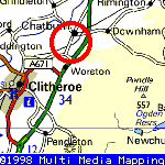
Where is Chatburn?
 |
It also gives you a pretty good weather forecast for the area.
Chatburn is 400 feet above sea level, situated in a hollow between two ridges which slope towards the Ribble just off the A59 Clitheroe to Skipton road on the outskirts of Clitheroe. The spire of the Parish Church, which was erected about 1838, dominates the village.

 |
Chatburn's new web pages are an exciting example of how innovative new technology can help bring a community together! These web pages will act as a front window for all the organisations in the village. They will allow villagers to keep in touch with the activities going on in the area and they will be a boost to tourism and a new virtual lifeline to all its e-customers at home and abroad. The web pages are now a definitive link to Chatburn's proud history and its dynamic future.
Nigel Evans MP
Ribble Valley
 |
An aerial view of Chatburn, click the photo for a larger image of the village.
Note: Please minimise the pop-up advertisement which appears in a window at the top of the screen, if you close the window, it will keep returning. Sorry but that's the price of free web hosting.


Top of Page